Topic 2
Network-based Megaregion Research and Regional Planning
Research Question:
This research explores the overarching question, “How are megaregions developed, evolved, and governed through planning?” It delves into the structural and interactive complexities within megaregions, particularly focusing on how these large-scale urban or rural areas can be mapped and managed using advanced network and data analysis techniques.
My Work:
My contributions to this field involve leveraging network theory, big data analytics, and spatial analysis to gain insights into the development dynamics and governance mechanisms of megaregions like the Pearl River Delta and the Guangdong-Hong Kong-Macao Greater Bay Area. By studying these areas, I aim to enhance the understanding of regional interconnectivity and the spatial distribution of economic and social activities within these vast urban clusters.
Research Method:
-
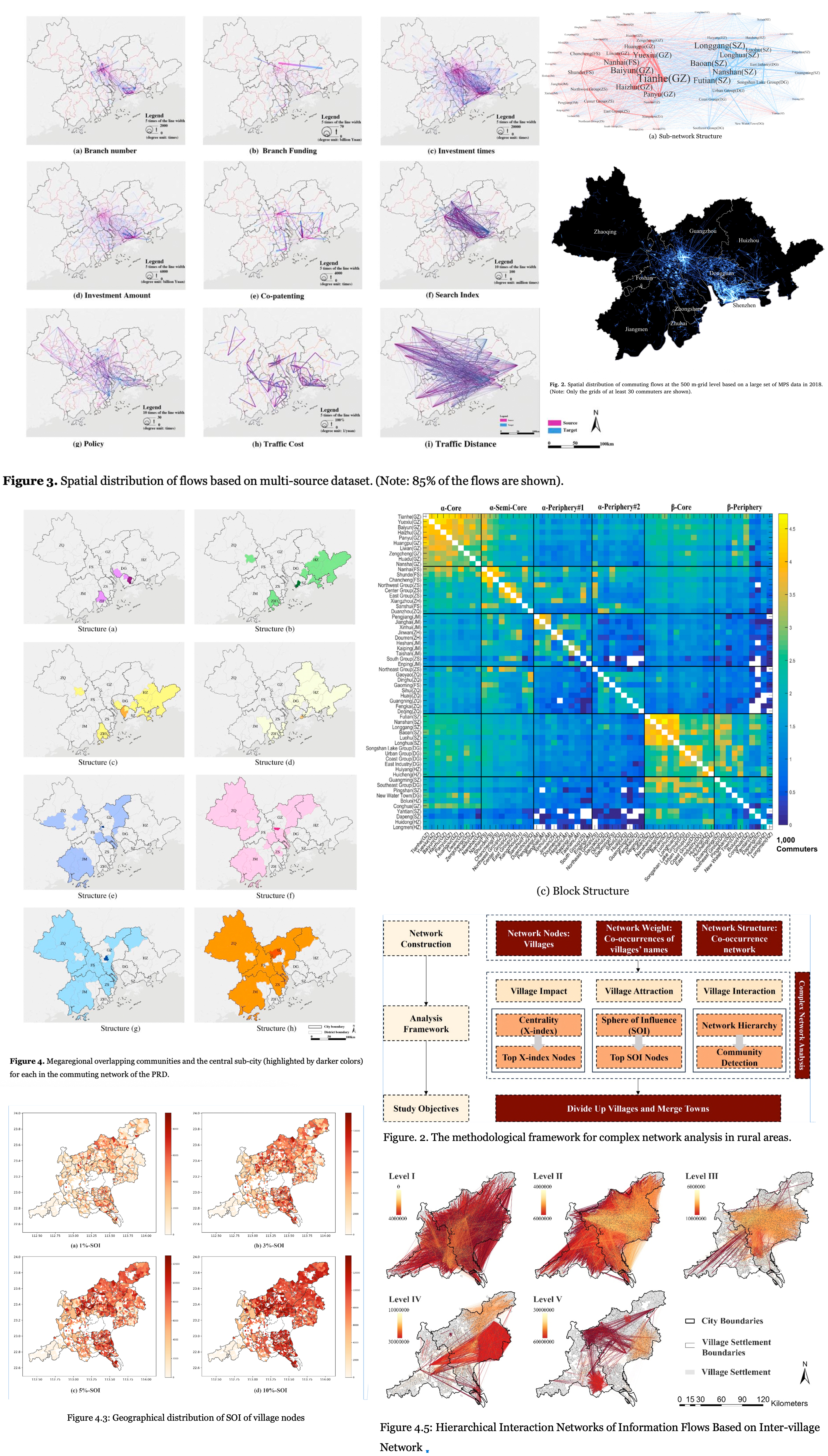
Complex Network Analysis: This approach utilizes mobile phone signal data to analyze the connectivity and network structures within megaregions, quantifying inter-regional interactions to understand regional cohesion and socio-economic diffusion. Techniques include the Weighted Stochastic Block Model (WSBM), which deciphers community structures and enhances understanding of spatial configurations, and Overlapping Community Detection based on Density Peaks (OCDDP), which identifies overlapping communities within commuting networks, revealing the intricate roles and interactions of urban nodes.
-
Webometrics and Big Data Analysis: used to explore inter-city/village relationships and measure city/village impacts within megaregions, providing a foundation for targeted rural revitalization and integration strategies.
-
Multi-Scale Analysis: employed to understand the roles of cities at different administrative levels within megaregions. The Re-Weighted Louvain Algorithm and mobile phone data provide insights into how administrative boundaries influence commuting and interaction patterns.
Several selected studies include:
-
Zhang, W.*, Fang, C., Zhou, L., & Zhu, J. (2020). Measuring megaregional structure in the Pearl River Delta by mobile phone signaling data: A complex network approach. Cities, 104, 102809.https://doi.org/10.1016/j.cities.2020.102809
-
Lin, J.*, Zhou, L., Du, C. (2018). Strategy Thinking on Using Land for Collective Construction from Perspective of Rural Revitalization [J]. Agricultural Economics and Management, (05):5-10. https://doi.org/10.3969/j.issn.1674-9189.2018.05.001
-
Fang, C., Gu, X., Zhou, L.*, Zhang, W., Liu, X., Liu, S., Werner, M. (2024). Exploring Spatial Complexity: Overlapping Communities in South China’s Megaregion with Big Geospatial Data. Computers, Environment and Urban Systems, Accepted.
-
Zhou, L., Gu, X., Fang, C.* Optimizing Rural Settlement Space Patterns through Webometrics Approach. (draft completed).
-
Fang, C., Chen, R., Zhou, L.* Comparing Variant Megaregional Complex Networks in the China Great Bay Area- A Multi-Scale Analysis Based on Mobile Phone Signaling Data. (draft completed).